from Our Lady's Mirror 1937 Winter Number:
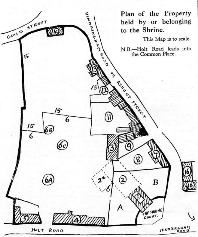
The accompanying plan has been drawn to enable readers to understand the relative position of the different parts of the
Shrine property. It has been prepared as donors often enquire about sites they have been asked to help us purchase. If
you look at the plan we will begin with A.B. which is the garden immediately around the present buildings of the Shrine.
This garden was given by Sir William Milner in 1931 to the College of Guardians, which was formed that year, for the
erection of the Sanctuary.
I. represents the Holy House enclosed in the outer Church (the shaded surround). 2. These dotted lines indicate the
extension which is being put up and 2a the Sacristies, etc. 3. Is the present Refectory, known to all pilgrims as the place
where we try to satisfy the “inner man”. 4. Is the Hospice of Our Lady while 5. are the barns where visitors sometimes
think of garaging their cars!
6a is the position of the Calvary. 6b of the Sepulchre. 6c of the Altar pavilion given by the late Lord Halifax. 6.6.6. show
the extent of this piece of property. 7. is the old Hospice of S. Augustine while 8 is its garden and 9 with the two
cottages (above the letter 9) is known as Army Yard.
All this piece of property 3 to 9 belongs to Sir William, who bought it about twelve years ago, to safeguard it for the
Shrine then in the Parish Church, and in the hope that we shall be able to buy it sooner or later. At the moment, this part
3 to 9 inclusive, is rented on a lease of 99 years from Sir William, with the option of buying it, whole or in reasonable
parts, at any time during that period. The dotted lines of 2 and 2a which represent the new buildings are shown to
encroach upon this rented property, but Sir William is making over, as a free gift to the Shrine, that part which is
required for the extension.
10. This black spot and the small space covered by the number 10 has for some time been our “Naboth’s vineyard” as it
represented the one space out of the control of the Guardians, on this “island” piece of land.
It has recently been acquired by us.
Numbers 11, 12, 13, 14 and 15 represent the old cottages and house with garden which came into the market two years
ago and for which we appealed for donations so that we might secure them for the future development of the precincts
of the Shrine. For these parts of the “estate” 10, 11, 12, 13, 14 and 15 we have had to raise the sum of £1,900 of which
£1,100 has already been contributed. The plot No. 11 is the site of the old pilgrim Hospice, the Bolt and Tun. No. 13, 14
and 15.15 represents the Croft, a delightful 15th or early 16th century house and grounds the “reversion” of which was
bought and presented to the Shrine in 1935 by an anonymous donor in response to our appeal. 13. is the house 14. is a
barn while 15.15 represents the extent of the Croft grounds.
Nos. 16 and 16, are some more condemned cottages which extend beyond the plan shown, down to the river Stiffkey.
These came onto the market about four years ago and were to be converted into public garages and a fried fish shop!
The Administrator and Bursar felt it was incumbent upon them to endeavour to save a site so near the “West” end of the
Shrine from such ugly neighbours and these cottages, six in all with a large garden were secured in the hopes that ere
long an Hospice will be built to provide a home for aged and lonely Priests where their declining years may be lived in
the practice of their religion and among friends. This of course remains to be built and, obviously, endowed.